In the competitive landscape of real estate, standard eye-level photography is no longer enough to capture the true essence of a property. Aerial drone photography has transitioned from a high-tech novelty to an absolute necessity for agents looking to provide a comprehensive visual narrative.
1. Unmatched Scale and Perspective
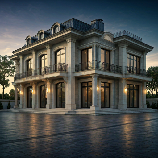
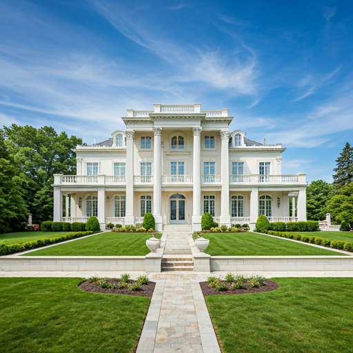
A ground-level photo can show a beautiful facade, but an aerial shot reveals the masterpiece in its entirety. It communicates the footprint of the home, the sprawling lawns, and the architectural symmetry that simply cannot be captured from the driveway.
2. Context is King
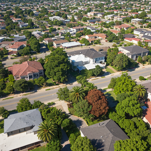
Buyers aren't just purchasing a house; they are investing in a location. Aerial photography provides vital context: How close is the property to the coastline? Does it back onto a protected forest? Is the neighborhood layout prestigious and quiet?
Neighborhood Narratives
Showing the surrounding area builds trust. Prospective buyers can see the walking paths, the proximity to high-end shopping districts, and the overall vibe of the community before they even book a viewing.
3. Highlighting Yard Features
Tennis courts, guest houses, fire pits, and intricate garden paths often look disjointed in standard shots. Drone photography stitches these elements together, presenting the outdoor living space as a cohesive sanctuary.
The Statistical Advantage
Real estate listings featuring professional drone imagery see a 68% faster sales rate compared to those with ground-level shots only. Don't leave a high-stakes sale to ground-level coverage.
4. Brand Authority and Buyer Trust
Utilizing advanced technology like drones signals to your clients that you are a modern, high-performance agent. It elevates your brand, making every listing feel like a cinematic feature.

5. The Safety of Professionalism: FAA Part 107
While drones are accessible, commercial flight requires strict adherence to safety regulations. At NS Visuals Estate, all our pilots are FAA Part 107 Certified. This ensures that your marketing is not only beautiful but fully compliant with federal law, protecting you and your clients from potential liabilities.
Understanding FAA Part 107 Requirements
The Federal Aviation Administration (FAA) requires commercial drone operations to comply with Part 107 regulations. This includes: remote pilot certification (passing a written exam), maintaining visual line of sight with the drone, limiting flights to below 400 feet above ground level, and following specific operational procedures around airports and populated areas. For Bay Area real estate professionals, drone photography must be conducted by certified pilots who understand local airspace restrictions around San Francisco International Airport, Oakland International, and other controlled airspace.
Professional drone real estate photography companies maintain insurance, stay current with regulations, and follow strict safety protocols. Uncertified operators using recreational drones for commercial purposes face federal penalties up to $250,000. The investment in professional, FAA-compliant drone photography ensures your marketing materials are legally sound.
Property Types That Benefit Most From Aerial Imagery
Not every property needs drone photography, but certain types benefit significantly from aerial perspective. Large estates with acreage, waterfront properties, and homes with distinctive landscaping show dramatically better with aerial shots. In the Bay Area, properties in Marin County, the Peninsula, and Silicon Valley often feature:
- Multi-Acre Estates: Drone imagery reveals the full scale and privacy of larger properties that ground-level photos cannot convey.
- Waterfront Properties: Aerial shots showcase proximity to bay, ocean, or creek features that drive buyer interest.
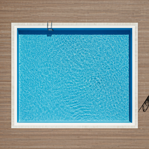
- Properties with Guest Houses or Pools: Drones reveal the complete layout of amenities and outdoor living spaces.
- Architectural Masterpieces: Modern homes with distinctive rooflines and architectural features are best appreciated from above.
- Development Land: Vacant or raw land requires aerial context for potential buyers to visualize development possibilities.
Seasonal Timing for Optimal Drone Footage
The Bay Area's Mediterranean climate offers year-round drone photography opportunities, but seasonal timing impacts the quality and appeal of aerial real estate media. Spring (March-May) features fresh landscaping and green hills. Summer (June-August) provides clear skies and dramatic cloud formations but may show brown hills. Fall (September-October) offers golden light and moderate heat. Winter (November-February) includes occasional dramatic cloud formations but may feature overcast skies.
Professional real estate photographers coordinate drone shoots with weather patterns and property-specific considerations. Homes with mature trees showcase better in late spring when foliage is full. Waterfront properties photograph beautifully year-round. For Bay Area listings, scheduling drone photography at the optimal seasonal moment often means the difference between good aerial images and extraordinary ones that move markets.
Integrating Drone Footage Into Comprehensive Listing Marketing
Professional drone real estate photography works best as part of a comprehensive visual marketing strategy. The ideal approach combines still imagery with listing video. High-resolution drone stills become gallery photos in MLS listings and property portals. Drone video creates emotionally engaging content for YouTube, social media, and property websites. When buyers see an aerial overview of a property's location within the neighborhood context, followed by ground-level photography revealing interior design, they develop a more complete and compelling sense of the property.
For Bay Area real estate professionals, drone photography + professional interior photography + twilight sessions create a marketing package that positions listings at the premium end of the market. Many high-value transactions are initially driven by a viral drone shot that generates buyer interest, which then converts through beautiful interior imagery.
Cost vs. Value Analysis for Drone Real Estate Photography
Professional drone real estate photography typically costs $500-$1,500 depending on property size, complexity, and whether video is included. This investment pays dividends particularly for properties above $1.5M where an additional showing or higher offer directly justifies the cost. Properties featuring striking aerial perspectives often see 50%+ increases in online inquiries within the first week.
Consider this comparison: A property that sells 10 days faster thanks to drone photography saves carrying costs (mortgage, taxes, insurance) that often exceed $2,000. A single additional buyer generated by compelling drone imagery can create competition that results in a $25,000+ higher final offer. For real estate in the Bay Area, drone photography is not an optional upgrade—it's a core component of competitive marketing strategy.
Learn more about our FAA Part 107 certified drone photography services and how aerial imagery can elevate your Bay Area listings.